 3 weeks ago I got a call to go on a trip up to the Icefall Lodge north of Golden, BC for a magazine article. Since I had pretty much nothing going on at the time I said "yes" to this and planned my travel last minute to meet the crew for this once in a lifetime adventure. The Icefall Lodge is BC's newest backcountry lodge and offers access to the highest peaks and largest skiable terrain of any lodge in BC. I met Rico (the writer), Doug (the photographer), Jeff (skier), Erica (skier), and Jimmy (Rico's buddy) at a motel in Golden the night before we headed out to the lodge. We drove about 40 minutes north of Golden, BC to rendezvous with the helicopter for a lift into the lodge. We ditched our cars and jumped in the helicopter for a 20 minute flight straight to heaven. After flying past hundreds of mountains we finally rounded the cornner and caught our first glimpse of the lodge. In the photo below you can just make out the lodge directly in the middle of the shot nestled in the trees to the left of the most prominent avalanche path.
 This shot is slightly closer to the lodge and shows the several structures that Icefall Lodge has. The old lodge is off to the right and the new lodge is the larger building to the left. As you can see, the Icefall Lodge is situated in the heart of some awesome ski terrain. Three feet of snow fell in the 2 days prior to our arrival and the skiing was incredibly good the entire time we were there.
 Here's the view from the 2nd floor of the lodge with another load being brought in from the heli. The heli pad is about 20 feet from the building making for some really dramatic heli drops. Sometimes we'd even start our ski runs from the heli pad in the morning.
 Here's the main Icefall Lodge from the heli pad. This lodge is about 2 years old and has more than doubled the capacity and comfort level at Icefall. The building is three stories tall with a drying room and the woodstove on the ground floor, kitchen and dining area on the 2nd floor, and bedrooms on the 3rd floor. It is important to note that this roof was great for jumping off and Jeff and I took advantage of that later in the week. Our group stayed in the old lodge which was about 100 feet to the right of this one and was no less comfortable, just smaller... In the photo below people are getting ready to head out for a clear day of powder skiing.
 Our first day at the lodge was spent skiing powder around the lodge getting a feel for the snow and terrain. Our second day broke bluebird and we headed off to the Lyell hut which iss located about 8 kilometers and 4500 vertical feet from the Icefall Lodge. The basis for the article is the hut to hut traverse that is an option at Icefall. There are actually three huts operated by Icefall lodge including the Icefall, Lyell, and Mons huts. The Lyell and Mons huts are at much higher elevation than the Icefall and are both located near some serious glaciated terrain. So we set off with the goal of reaching the Lyell hut. We hiked up into the alpine and got some incredible views on our way...
 Early morning in January lends itself to some long shadows. Here we're looking at Mt. LaClytte and our route towards the Lyell Icefield. Lots of terrain up here.
 Hours later and we're almost up to the col (pass) where we'll head over a ridge and onto the Lyell Icefield. In the photo below Rico, Jimmy, and Erica make their way up the skin track towards Crampon Col. The views of the mountains only got more incredible the higher we got.
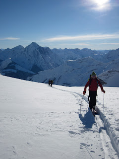 Jeff Annetts nears Crampon Col after hours of hiking through some unbelievable mountains and glaciated terrain. One the other side of the low spot on the lookers right is the Lyell Icefield.
 After going up and over the Crampon Col we hiked straight across the Lyell Icefield and up the Lyell Hut. In the photo below lodge owner Larry Dolecki takes the last few steps towards the Lyell hut. This hut sits at about 10,000 feet just west of the continental divide. The lodge is quite rustic but it has a propane heater and stove making it surprisingly comfortable, even when its -10 degrees outside...
 We spent the night at the Lyell hut and headed out for a ski the next day. It was really, really cold the next day and the winds had picked up making for some barely tolerable temperatures. We decided on a quick and easy objective in Lyell 5 or Christian Peak, 11,154 ft. We made quick work of this summit and decided to head back to the Icefall lodge for some more deep powder skiing and more comfortable temperatures. While the Lyell hut was truly incredible, the snow and weather conditions were not ideal for us to stay there and get photos. Another storm was rolling in and we had some powder to ski... In the photo below you can see the amazing scenery as well as people swinging their legs in an effort to prevent frostbite to their toes... This was the coldest I have been in years.
 After another long day of touring to get back to the lodge we found ourselves back at Icefall and sweet comfort. Here's a shot of the second floor of the lodge. The kitchen is just out of sight to the right and the common area/dining area is where everyone is sitting.
 Just downstairs from the dining area/kitchen is the drying room and wood stove. This wood stove keeps the entire three story building warm with no problems. There is a drying room for your boots and gear that can accommodate everyone's gear and then some. Directly out in front of the door is the heli pad and the start of some of the ski runs.
 We were getting absolutely dumped on while we were up there, almost 4 feet of snow fell while were there, on top of three feet the week before! The conditions were incredible for shooting ski photos and just begged for the obligatory roof huck. Since the building was three stories high we figured the roof jump was about 30 feet. We also jumped off the other roofs, but the main lodge had the best landing and biggest drop. Getting onto the roof was scarier than jumping off it. This ladder was straight up and climbing it in plastic ski boots was no easy task. After climbing up we had to pull our skis up on a rope as seen in the photo below.
 All around the lodge was great skiing, and since the snow kept coming the skiing only got better and better. We enjoyed the pillows, trees, and chutes that were easily accessible from the lodge and played it safe with the increasing avalanche danger. Luckily the lodge has a good deal of protected tree skiing that is right near the lodge, we had plenty to do while it was storming... In the photo below Rico (look closely) shreds the crap shoot in epic conditions.
 We were busy shooting photos most of the time, but Jeff and I found some fun cliffs to jump off of. I'm pretty sure we got some good shots for the magazine, but I could barely see anything the whole time we were there since the snow was so deep, so I'm not really sure. In the photo below Jeff takes a little air...
Jeff Annetts get a deep turn in some of the pillow near the lodge. I didn't take too many pictures of the skiing since we had a professional photographer with us the whole time, but this photo is a good representation of what the skiing was like the whole time. Deep, some of the deepest snow I have ever skied.
 After days and days of heavy snowfall we finally got to see the raw power of mother nature. While we were skiing in the trees, to avoid avalanche terrain, an enormous avalanche swept down the Kitchen Chute just feet from where we were skiing. It was an unexpected and shocking thing to have happen, and luckily we were all well within the old growth trees for just that reason. I've never been that close to an avalanche this big and it definitely was a little scary. The photo below shows the avalanche path and just how close we were to it. There's 20 foot tall trees in the debris... Not only was this scary but it was also awesome to see something like this up close while being completely safe and out of its way.
  My trip to Icefall could not have been any better. It was definitely one the best trip I've been on in years. I can't wait to go back, there's so much more to explore...
 About an hour later we're still about an hour from the bottom of the couloirs. The East Couloir coming into view on the lookers left, and the St. Jean, in the center of the photo. The scale of things down here is really deceptive. What looks like a short distance often turns out to be much farther and steeper than it seems...
 Here is a view of our primary descent objective, the East Couloir. On a big year this line has a 70 foot rappel over an ice bulge at the bottom, this year it has about a 400 foot rappel over ice, rock, more ice, more rock... it just isn't that filled in, so we changed our plan. Maybe we'll come back and tag this classic line another year.
  So we head up the St. Jean couloir in hopes that the snow will be good in this aesthetic, steep, skinny couloir. About a quarter of the way up we find about a half inch of water ice on top of the snow in the chute, fine conditions for climbing in crampons, not so sweet for attempting to ski down. Here's a view looking up the chute....
 Eventually the crew made it to the summit of Split Mountain. Andrew, Oscar, Duncan and myself are all pretty wiped out at this point. We'd explored all of the ways down the mountain that we weren't willing to go down, so we opted for the "easy" way down, which we had to pretty much figure out as we went. It turned out to be pretty decent skiing, and far less life threatening than either of the other options we'd explored that day.
  About 11 hours after leaving the car that morning we returned safe and sound. 7,500 vertical foot runs are lots of fun, especially when you carry ropes and harnesses most of the way for no good reason, I guess we all could use a little extra exercise...
  In any event, skiing Split Mountain was something I've wanted to do for a while, and I'm thankful to my friend Andrew for providing the motivation I needed. Hopefully the next time I head that way there will be appropriate snow conditions for getting after the more aggressive lines.
  Our next objective was the summit of Birch Mountain, and as usual this mission started with a healthy little dose of desert walking. In the photo below Oscar makes his way towards the snow just after leaving the car at the end of the dirt road at 6,500 feet. The summit of Birch Mountain is 13,658 ft., so the climb and the ski run are 7,000 vertical feet. Unlike Split Mountain, Birch is not set back on the crest, so the fall line is quite a bit more direct making for a quicker climb and a much quicker descent, depending on your route. Birch Mountain is on the right, Mt. Tenemaha is on the left. Its hard to tell from the photo, but Birch is 1,000 feet taller than Tenemaha.
  About a third of the way up the mountain and I can't get over the contrast of the snow and the desert. Here Oscar is bootpacking up with the snow and the desert making things interesting in the background.
 Near the top of Birch the views were pretty phenomenal, here Oscar skins with Split Mountain dominating the skyline behind him. Our descent route from two days earlier is visible in this shot. Again, it is hard to capture the scale of everything in a photo, these mountains are absolutely enormous...
 After about 5 and half hours we reached the summit of Birch Mountain and were awed by the view. The Palisades to the North, Split Mountain and the other high peaks to the south was just too much for my camera to take in. My computer almost exploded when I downloaded all the photos, and in fact I lost about 40 shots in the process. Oh well. Luckily, Oscar captured a shot of me on the summit of Birch scoping out the downclimb to get into the line we wanted to ski.


 After skiing such incredible snow we decided on another lap off the top and headed back up. We dropped into the steep entrance of the Cross and enjoyed a continuous 3,000 foot run of creamy but somewhat variable powder. It was especially fun for me since I have never entered the Cross from this particular spot, and doing something new is always fun for me. The cold powder snow changed significantly throughout the course of our day on Tallac, and unfortunately it seems like we may have milked it for all that it was worth. However, all is not lost, since we live in California we'll be skiing corn in just a matter of days....

 Here we're getting ready to drop into another perfect pow run after skiing the line on the left in the background. It was a beautiful day out there today, sunny all morning with some high clouds moving in this afternoon bringing another overnight refresher... It has actually already started snowing again...


